(this page is slow to load due to the large map images below)
Maps may be displayed with or without attached tabular data.
The standard installation includes "24 bit" maps with tens of thousands of colors.
See Nova for Windows' image gallery
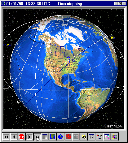
The View from Space shows a view of the Earth
as seen from an orbiting spacecraft.
Nova for Windows' color maps are derived from NOAA high-resolution (~10 km/pixel)
multi-channel AVHRR images.
They provide realistic views of the Earth with colors representing real vegitation
patterns and topography.
The View from Space may include footprints, ground tracks, orbits, spacecraft markers in
space, etc.
You have complete control over the appearance of the map and you can display as many
satellites as desired.

The Rectangular Map displays almost the whole Earth at a glance (except the Poles).
Based on a modified Miller projection, the Rectangular Map features optional political
boundaries,
lat/lon grid, unlimited satellites and observers, plus satellite footprints in two formats
(normal and "NASA").

The Rectangular Map may be zoomed into any continent for a close-up view.
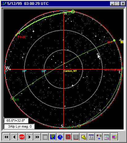
Nova for Windows includes the exclusive Radar Map with accurate star map..
It displays the sky with the main Observer at the center of the screen.
The perimeter of the circle is the horizon, with North at the top.
Satellites pass across the "radar" screen in real time so you can see at a
glance which satellites
are above the horizon at any moment.
If an autotracking interface is connected to Nova for Windows, the antenna's position is
displayed as well.

Nova for Windows also includes maps of equivalent sky temperature ("Sky Noise
maps").
Maps for 50, 130, ad 400 MHz are included.
These maps display satellites projected against the natural noise from emissions of stars
throughout the sky.
This noise can degrade system link performance if excessive.